

Description
HX-1 Device Overview
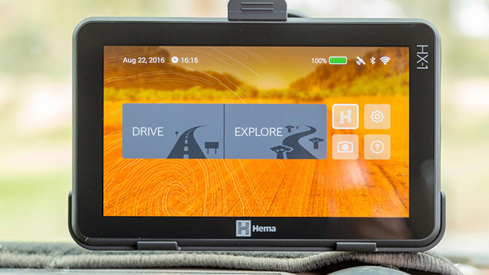
The HX-1 features a large 7-inch multi-touch screen with a bright 1024×600 pixel display, which is reinforced with a tempered glass screen protector for added durability. A powerful 1GB RAM makes the HX-1 impressively fast, while a 5000mAh battery will keep you exploring for up to 6 hours off charge with continuous use. On the reverse is a 5-megapixel camera, which allows you to capture your adventure with geotagged photos and video up to 480p at 15 frames per second. Meanwhile, the HX-1’s Wi-Fi connectivity makes downloading additional maps, content and device updates quick and easy, so you can spend less time indoors and more time exploring off the beaten track.
HARDWARE
Unit Dimensions, WxHxD: 187mm x 115mm x 17mm
Display size: 7″ diag (17.7 cm)
Display resolution: 1024 x 600
Battery: 5000mAh Lithium Polymer rechargeable
Battery life: 5 hours off charge with continuous use, depending on settings
Connections: 3.5mm stereo jack, microSD card slot, Mini USB
External audio: 8Ω, 1.5W speaker, microphone
Buttons: Power button
Camera: 5-megapixel rear-facing
Processor: MediaTek MT8127 Quad-core ARM Cortex-A7 MPCore, 1.3GHZ, GPU: Mali-450 MP2
Operating System: Android 4.4
Warranty: 12 month warranty (conditions apply)
SYSTEM MEMORY
Internal memory: 16GB
RAM: 1GB
Expandable memory: Accepts microSD up to 32GB
COMMUNICATIONS
USB: Mini USB 2.0 data and charge
Bluetooth: Bluetooth 3.0 HS, Bluetooth 4.0 LE
Wireless: IEEE 802.11/b/g/n
GPS: MT6627, 22 channels tracking
DRIVE MODE
Preloaded Maps: Australia & New Zealand mapping
Data providers: HERE road data & Hema track data
Map Updates: 3 years free
Navigation: Turn-by-turn voice guidance
Warnings & Alerts: Red light cameras, speed cameras, timed school zones, speed warnings
Visual guidance: Lane guidance, 3D buildings & landmarks
Points of interest: 6000 Camps Australia Wide & Caravan Parks Australia Wide, 40,000 Hema-verified POI, HERE POI
Trip recording: Record track logs, mark & save locations
EXPLORE MODE
Preloaded maps:
Maps available for free download:
Map updates:
Free for the life of the unit
Points of interest:
40,000 Hema-verified POI (accommodation, campsites, caravan parks, dump points, wineries, lookouts, picnic areas, rest areas, toilets, water points, boat ramps, emergency telephones, mechanical repairs, medical facilities, police stations, post offices, public telephones, parks & wildlife, ranger stations, visitor centres, historical points, 24-hour fuel, general stores, roadhouses)
Trip monitoring: Real-time location tracking & heading
Trip recording: Record track logs, drop & save waypoints, capture geotagged photos & videos, write trip notes
Trip sharing: Sync trip data to your online Hema Explorer Cloud account
Routing:
PACKAGE INCLUDES

Reviews
There are no reviews yet.